 GeologyRocks
Sandstone formation
- Login to post a new forum topic.
Rank:

Contact:


No need to apologies for
Fri, 09/12/2008 - 10:52No need to apologies for being curious and seeking advise! 
To your question. I am not from England and not familiar with the local geology. Without the proper terms your description of the quarry is not that helpful. That is nothing bad. Geologists need years of experience and studying to get that right. Perhaps someone who has seen the region can give better advise. I can only ask you for a good foto of the quarry and the rock layers described by you. Fotos tell us more than a thousands words (well not always but usually).
But let me take a guess. The crazy angles might be stratification of the sand layers indicated a flow regime in moving water. The layers getting thinner may indicate that the source of the sand is becoming more distant and less sand is being deposited - or may simply show us that accomodation space is becoming smaller because the basin the sands got deposited into is almost full. Strong internal stratification of the sand layers may indicate more shallow water.
Well for me it is normal to like touching rocks. Coal is always (few exceptions) found near or in sedimentary rocks like sandstone, shale and siltstone. They can often form in the same or similiar places and conditions.

Rank:

Roles:


Contact:

haughtongreen
Fri, 09/12/2008 - 20:19Apologies for intruding on you good people when my specialist interest is not geology but....
No apology needed
I climbed up to it yesterday and was fascinated by one large (probably 3' square) piece of stone that was sat by the quarry face. It was if it had been hewn from the cliff minutes before I had arrived, if was so perfect, and then abandoned. I have no idea whether it had been partially dressed to look as perfect as it did, or if large blocks could be extracted that perfect to start with. Anyway, the lower part of the cliff look as if there was very little stratification and would have yielded more similar sized blocks (Though perhaps it was nearly worked out) but suddenly, going upwards, a point is reach where there is massive stratification, the layers being perhaps a centimetre thick on average. It would have been utterly useless for building material, I imagine. So what is going on here? What suddenly changed to cause this major stratification whilst everything below is solid? The layers are all at crazy angles, by the way, so lots of stuff been happening here and it is great to look at and to touch (Is it normal to enjoy touching rocks? lol).
The UK coalfields are Carboniferous in age ~300 million years ago. They form from massive river deltas, like the Mississippi delta and the Rhone delta today, stuffed full of vegetation. The deltas brought sediment (the sand) and dumped it into the sea. However, things don't stay the same forever. Sea levels rise and fall, rivers channels switch, flood and get closed off. This is what is causing the changes in the beds you observed. The lower beds are massive sandstones, probably part of the lower delta (although the exact formation of massive sandstones is debatable). As the river flows over the region, you find more thinly bedded sandstone with cross bedding (the crazy lines, probably), with channels cutting through older beds. Anything like these pictures?
/images/cross_bedding
/images/channel_and_wash_out
/images/cambrian_cross_beds
/images/cross_beds_with_topsets_foresets_and_downlap
How do we know there were plants? The coal and sandstone contain a lot of plant fossils like this one:
/images/lepidodenron
Also, are coal and sandstone usually found near to each other?
Yes. Have a Google for cyclothem and coal formation in general.
Hope that is useful
Rank:

Roles:
Contact:
In the north of England
Fri, 09/12/2008 - 20:46In the north of England (can't speak for elsewhere), coal and sandstone are often very closely associated. In mid to late Carboniferous times, a series of river deltas advanced from the north filling in the limestone-producing seas that dominated early carboniferous times. The normal progression of rocks is deep water shales and fine sandstones (the furthest, deepest reaches of the delta), overlain by shallow water coarse sandstones (the shallower, nearshore areas), overlain by the coal measures (the delta top, which is growing vegetation). This is really simplified- sea level changes and delta subsidence mean that cycles can repeat time and time again, but it gives the general idea.
The rocks you're talking about sound typical of the millstone grit- the shallow water coarse sandstone. Conditions would have been quite variable- offshore sandbars, delta channels, varying depths. The chaotic bedding sounds like cross bedding. Does it look anything like this? That's caused by deposition in flowing water of some kind. I daren't say for sure what kind without taking a look at your exposure, but in the millstone grit it's often water depositing sand in inclined sheets as it enters a deeper area and loses speed. Changes in texture like you're talking about could easily be caused by some change in conditions. Shifting sandbars, meandering delta channels etc...
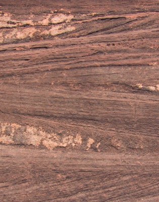
I can't really say much more without seeing the exposure, and even then I wouldn't promise!
Hope this helps. Ask if you're not clear about anything
Oh, and it's fine to enjoy touching rocks, just as long as it's in moderation!
edit: damn, way too slow. Jon beat me to it!
Rank:

Contact:
Sandstone
Sat, 09/13/2008 - 01:59Thanks very much for your replies. Very interesting. So we have a river delta and, obviously really, the vegetation ends up as coal and all the tiny fragments of rock washed down become sandstone. Yes, I see what you mean about the process being repeated several times as well. Hence a coal seam, and then rock, then another coal seam, and so on, in a coal mine. The area is littered with old pits; drift, bell and shaft.
I took a couple of pictures of this disused quarry the other day and you can find them here. I don't think that anything in them contradicts what you have suggested. Unfortunately, they were taken with my mobile phone, so they lack the clarity and rishness of colour that I would have got with my proper camera. The colour of the stone is deep and rich.
By the way, it was the large block in the second picture that got this somewhat overweight, middle aged man risking life and limb up a sandstone cliff lol. It put me in mind of the unfinished oblisks that can still be seen in the quarries of Egypt. I was trying to imagine the day that the quarry closed, perhaps when this rock had just been liberated from the rest of the cliff and was waiting to be dressed. And still it waits.
So, does sandstone always contain fossils? I would love to seek some out in these deposits. Not a clue how to go about it though. When I was at school we were taken on a field trip into limestone country and the fossils almost seemed to find you there, there were so many!
There are the foundations of a disused coal mine nearby that I have a hankering to draw to scale. Anyone know how to go about that single handed with just a pen, paper and a tape measure?
Brian.

Rank:

Roles:
Contact:
sands
Sat, 09/13/2008 - 21:34Thanks very much for your replies. Very interesting. So we have a river delta and, obviously really, the vegetation ends up as coal and all the tiny fragments of rock washed down become sandstone. Yes, I see what you mean about the process being repeated several times as well. Hence a coal seam, and then rock, then another coal seam, and so on, in a coal mine. The area is littered with old pits; drift, bell and shaft.
I've just looked at the geology map of Haughton Green and it is one mass of coal seams. If you can let me know where the quarry is I might be able to find out more about the sandstone.
So, does sandstone always contain fossils? I would love to seek some out in these deposits. Not a clue how to go about it though. When I was at school we were taken on a field trip into limestone country and the fossils almost seemed to find you there, there were so many!
Not all sandstones are fossiliferous. River delta sands tend to be poor as the chance of preserving stuff is poor. The limestone you saw was deposited in a quiet shallow sea, much better chance of preserving fossils. The coal measure sandstones might contain the odd plant fragment but that would likely be it.
There are the foundations of a disused coal mine nearby that I have a hankering to draw to scale. Anyone know how to go about that single handed with just a pen, paper and a tape measure?
Depends on how big it is. If at least moderate in size I'd find it in google earth, print the image and measure the features on the ground
Rank:
Contact:
Sandstone
Sun, 09/14/2008 - 15:19Thanks for the reply! Is there anywhere online that I could view the geological map of the area? Yes, it was riddled with coal mines once.
The sandstone quarry is located at approximately SJ929 931. I have placed some pictures of the rock formations at http://www.thesectionalappendix.co.uk/sandstone.html
There is also a page about the disused colliery that I mentioned at http://www.thesectionalappendix.co.uk/hulmespit.html Apparently the foundations were excavated in c.1970, but I can find no information about what they found and the interpretation board has long ago been vandalised.
What I am intending to do (If I fail to find the report from the dig) is to map the foundations. The idea that comes to mind is tent pegs and string to create a grid and then copy it to graph paper. Unfortunately the site is competely overlooked by trees, so it is impossible to get any help from Google Earth. The mine ended its life as a pumping station to drain water from the nearby Denton Colliery. Both closed in 1929 after the general strike, during which they had become flooded.
More info can be found at: http://www.pittdixon.go-plus.net/hulmes-pit/hulmes-pit.htm
And more pictures as it was when it was still standing at: http://www.pittdixon.go-plus.net/hulmes-pit/gallery.htm
Brian.
Rank:
Roles:
Contact:
Haughton Green
Mon, 09/15/2008 - 21:49It appears to be a sandstone towards the top of the Upper Carboniferous [Langsettian (Westphalian A)] Lower Coal Measures called the Blenfire Rock. There are coals directly above and below it.
The outcrop trends NNE and appears to form the ridge that eastern Haughton Green sits on.
Unfortunately the online resources that I use are behind a paywall so I can't post any maps (BGS maps cost £12 from www.bgs.ac.uk).
Google appears to be little use about the Blenfire Rock other than an OU field trip report to Glodwick Lows, near Oldham, confirming that it is a braided river delta deposit. You might try to find the local geological memoir in your local library for more information.
Rank:
Roles:
Contact:
Hulme's Pit
Mon, 09/15/2008 - 22:43The map for Hulme's pit on the website you give appears to be derived from the 1:2500 County Series Revision 1 (circa 1909). The mine buildings are *slightly* better defined on the Second revision Lancashire & Furness (1922) sheet if you can track it down.
Rank:

Contact:

Sandstone formation
Submitted by haughtongreen on Fri, 09/12/2008 - 01:22.Apologies for intruding on you good people when my specialist interest is not geology but.... I have a question that you might be able to answer. I live in Haughton Green, Manchester, England. The area was once minded for coal, the last pit closing in 1929. Coal was found anywhere from surface level to quite deep, there being many faults and lots of hills. I believe that there have been drift, bell and proper pits throughout the area in the past. It is a part of the Lancashire coalfield. There are also the remains of a sandstone quarry nearby. I climbed up to it yesterday and was fascinated by one large (probably 3' square) piece of stone that was sat by the quarry face. It was if it had been hewn from the cliff minutes before I had arrived, if was so perfect, and then abandoned. I have no idea whether it had been partially dressed to look as perfect as it did, or if large blocks could be extracted that perfect to start with. Anyway, the lower part of the cliff look as if there was very little stratification and would have yielded more similar sized blocks (Though perhaps it was nearly worked out) but suddenly, going upwards, a point is reach where there is massive stratification, the layers being perhaps a centimetre thick on average. It would have been utterly useless for building material, I imagine. So what is going on here? What suddenly changed to cause this major stratification whilst everything below is solid? The layers are all at crazy angles, by the way, so lots of stuff been happening here and it is great to look at and to touch (Is it normal to enjoy touching rocks? lol). Also, are coal and sandstone usually found near to each other? Hope you can help. Brian.